It's time, people! Springtime. Time to hit the trail, because there's no better season for hiking in Northern California. This, of course, from a part of the USA that boasts great hiking year round, and from a guy that can make a good case for all seasons.
Do it now. Get off your lazy butt and get out there (that advice is more for me than it is for you). Yes, somedays winter still thinks it's winter. Yes, La Niña continues her rampage. Yes, we're all sick of the rain (except those back east, who are no doubt rolling their eyes at my words because they're all so freaking sick of the freaking mountains of snow!). Rest assured, though: across the country the Ice Queen is tiring, and the benevolent Goddess of Spring is tilting her beautiful, dewy, revitalizing, sparkling face to the rising sun.
So start walking, Ohio. Take a hike, New York. Open the door and step outside, Oregon. Do it now, Maryland. Same for you, Wyoming and Mississippi. Hey, South Dakota; yeah, you heard me. What you laughing at, Arizona? Check out your turf, your own back yard.
Then hightail it to San Francisco, California. When and if you do, and should you have a day to spare while you're here, why not take a little drive, a quick jaunt north to a landscape beyond compare, to the place chronicled in the following installments?
Okay...Maybe it's not so quick, or that little, but it really doesn't matter. You will not be disappointed.
Point Reyes National Spring
Forty miles north of San Francisco, in the western reaches of Marin County, is one of the Bay Area’s undisputed natural jewels, and one of our nation's best ideas ever. A lonely, sprawling wilderness of rolling hills, pastures and rugged coastline, of sand dunes, estuaries, wind-scoured beaches and fog-nestled forest. A tramp-o-rama paradise of trails for the taking. A magic peninsula of land, where the sounds of wildlife outnumber those of man, named Point Reyes National Seashore.
I spent April, May, and June 2003 exploring a small slice of the seventy-five thousand acres that make up this extraordinary stretch of California, but my eight forays into the park barely scratched the surface of the 150 miles of trails and 80 miles of coastline draped about the land, awaiting discovery. Sometimes alone, though mostly with friends in tow, I revisited a few familiar hikes and savored several new ones of startling beauty. Together we huffed and puffed up hills, ambled leisurely by lakes and streams, marveled at the abundance of flora and fauna. In the ever-shifting climate we shed layers of clothing one minute and bundled up the next. Breathing in the fresh air our minds were freed from the week’s worries.
The hikes further strengthened my appreciation for both the simplicity and grandeur of the natural world. They reaffirmed how lucky I am to live just over the hill from such a vast, unspoiled outdoor playground. On every hike I felt my soul refreshed. What follows are the highlights from an enchanting three months.
* * *
Hike #1, Monday April 7: Alamere Falls
The Vital Statistics
Coast Trail, Palomarin Trailhead to Alamere Falls
Distance: 8 miles roundtrip total, in and out.
Time: 4 to 5 hours, depending on how long you stay at the falls.
The Ouch Factor: A somewhat taxing hike and a full day out, with a few good uphill climbs and some intense scrambling if you want to get down to the falls (be careful).
At seven in the morning, after a weekend spent opening wine, chatting with guests and serving cocktails at Farallon Restaurant, I sprang from bed and started a pot of coffee, stumbling to the shower while it perked away. Dry and dressed and with a mug of Peets Costa Rica bubbling through my veins, I immediately packed up, choosing hiking gear for the day. I had made tentative plans for an outing, but the previous twenty-four hours had been cold, windy and cloudy so details were weather dependent. But, quelle chance, not a cloud in the sky! Calm, clear and bright: extremely lucky weather for Point Reyes National Seashore, our supposed destination, where the coastal fog can blot out the sun for weeks at a time.
In the first of several rental cars to come I crossed the Golden Gate Bridge and picked up my good friend Julie Ring in the town of Sausalito, stopped at Mollie Stones grocery store for turkey sandwiches and water, fruit and trail mix, preparing for a full day out. Together we drove less than an hour up the coast on CA Highway 1 to the southern end of the Point Reyes wilderness, past Stinson Beach and egret-dotted Bolinas Lagoon at low tide to the desolate, wind-swept end of Mesa Road. Several years before I had explored some of the northern areas of Point Reyes, but this was new territory for both of us. And it quickly proved amazing! Starting at the Palomarin Trailhead, the Coast Trail hugged the cliffs above the Pacific Ocean, passing through huge stands of eucalyptus and scruffy hillside chaparral. We could see for miles and miles: all the way up the undeveloped shore to Wildcat Beach, Limantour Beach, Drake’s Bay and the Point Reyes Headlands. The view was extraordinary! Offshore in the blue water a gray whale lazed hidden on the surface; only the misty blow belied its presence. We watched for a bit and then continued. Two hours-four miles in we hiked, passing a pair of freshwater lakes named Bass and Pelican (Bass is not for the fish, but instead supposedly a shortened version of Bare Ass).
Every bend in the trail seemed to hide some new surprise: Technicolor wildflowers burst all around us, butterflies flitted about, and wild hares hopped across the trail. We saw no other people, no houses, no cars, nothing, just the magnificent seashore and hills and cliffs that drop to the surf. The payoff was a place named Alamere Falls, a series of spring-fed cascades that end in a forty-foot waterfall directly onto the beach. Oh my!
Cautiously I scrambled down the eroded ruts to the top of the falls, then down an even scarier, crumbly, vertical gash in the cliff-face to the deserted beach to view the watery tumble from below. Julie stayed up on the bluffs; I joined her after a precarious climb back up and unpacked lunch. We sat and talked for an hour or so. What looked like two sea otters romped in the water beyond the surf, and a harbor seal explored nearby. The sun blazed. Smitten by the magnificent, surprising hike less than an hour from our home we vowed to return and repeatedly explore our way north over the coming months, christening our plans “Point Reyes National Spring”. Then we retraced our steps to the end of the Mesa Road for the drive back to San Francisco.
Somebody pinch me.
 |
| The view looking south |
 |
| Julie on the Coast Trail |
 |
| Pelican Lake |
 |
| Alamere Falls |
* * *
Hike #2, Monday April 14: Bear Valley
The Vital Statistics
Bear Valley Trail, Visitors Center to Arch Rock
Distance: About 8.5 miles round trip total, in and out.
Time: 4 hours, depending on how long you linger at the coast.
The Ouch Factor: Relatively easy fire road for most of the way with little elevation gain.
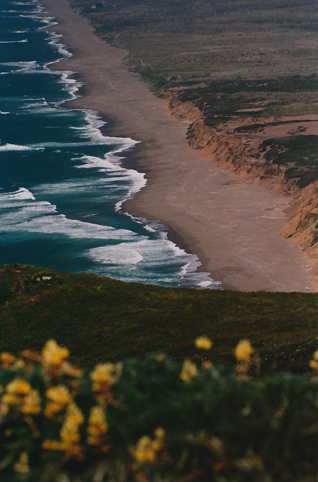
The best place for newcomers to begin a Point Reyes National Seashore excursion is the Bear Valley Visitor Center. It’s a large gray barn-like building; quite handsome but alarmingly built smack dab on the San Andreas Fault Rift Zone, just outside the quaint town of Olema. The displays of the local wildlife and ecology, the maps, books and ranger information inside are well worth the stop. This is also the beginning of the most popular hike in the park: Bear Valley Trail. Long and wide but mostly flat, with just a 200-foot elevation gain throughout, it is well traveled indeed. Amazing country however, so even this wheelchair-accessible fire road is packed with beauty. Although any season has its charms, spring is a great time to visit: the creeks and streams gurgle with run-off, moss drips from trees, a blanket of ferns unfurls on the forest floor, the sun sparkles through the canopy and ignites florescent green meadows.
We walked on a quiet Monday, 4.4 miles to Arch Rock on the Pacific Ocean, and the old wagon trail was practically (blessedly) deserted. Once again this was virgin territory for my friends Julie, Heidi (with her two young boys in an all-terrain stroller) and myself. Most of the tranquil walk was shaded by oak, California bay laurel and eucalyptus; our noses were inundated by the rich fertile scents of the forest as we strolled our way west toward the sea. After three and a half miles the trail narrowed, the dense growth overhead suddenly weakened and we were thrust into sunshine. Then we emerged on the bluffs and confronted our destination. The view above Arch Rock at the end of the trail was both a reassuringly familiar sight and a dazzling surprise. A deep, forested ravine sliced through the cliffs at the beach. Endless Pacific waves rolled in from the ocean to meet the fresh water draining off the hills. Rain clouds had all day gathered to the south of us, so gray and threatening that we had almost cancelled the outing, but the cliffs above the pounding surf were bathed in warm sunlight. Twenty-seven miles offshore the Farallon Islands peeked above the horizon. Sandwiches unpacked, our blanket spread out on the grass, we ate and relaxed and took in the surroundings. A small brown rodent (no idea what kind) popped its head up from the earth nearby, curiously checked us out, and then barricaded itself safe underground. Alamere Falls, the hike we had discovered just the week before, was visible well to our south, water still pouring over the cliff edge to the sand below. Drake’s Beach and Point Reyes loomed to the north, the sea stacks and rugged coastline of Sculptured Beach between our perch and the headlands closer today than last Monday. We will soon know these places as we now know Alamere Falls and Arch Rock, Divide Meadow and Pelican Lake, as we tramp our way north during subsequent outings of Point Reyes National Spring.
 |
| The view north to Sculptured & Santa Maria Beach |
 |
| In the distance: Point Reyes Headlands |
* * *
Hike #3, Sunday May 4: Sculptured Beach
The Vital Statistics
Beach Walk/Coast Trail, Limantour Beach to Sculptured Beach
Distance: 8 miles round trip total, in and out, but with a low tide you can make a loop of it by hiking the beach south all the way and taking the Coast Trail back.
Time: 4 hours, because you’ll want to spend some time exploring and perhaps eating lunch.
The Ouch Factor: Easy, with little elevation change.
Lingering, El Niño storm clouds darkened the morning sky as I walked to the corner of Lombard and Fillmore for the Golden Gate Transit bus into Sausalito, but behind them the sun peaked out hopefully. Rain so late in the season is rare in California. April 2003, however, poured over two hundred percent of normal precipitation; last weekend an easy hike through the old growth redwoods of Hendy Woods in Mendocino County turned decidedly more difficult as the trail became a series of small streams and ponds to be forded.
Finally the rain was meant to subside. With our destination once again the coast, Julie and I repeated the hour-long drive out Sir Francis Drake Boulevard to Bear Valley Road, this time past the visitor center to find Limantour Road, an eight-mile paved pathway to the beach. On the drive west we cruised through dense forest, scraggly chaparral and undulating green meadowland. As we neared the ocean, telltale signs of the Mount Vision forest fire that ravaged the area in 1995 emerged. The charred silver skeletons of Coast Redwood, Bishop Pine and Douglas Fir towered over the grass, lupine, cow parsnip and scrub that are steadily reclaiming the hills.
The parking lot at Limantour was already filling up with hardy souls when we arrived, stretched our legs, and waited for Don and Heidi and their two young sons Calvin and Lucas. Cream-colored Limantour Beach, and the long sand spit that separates the ocean from the fertile estuary behind it, was mottled with the shadows of fluffy, cotton ball clouds floating by overhead. Small ponds and seasonal wetlands dotted the landscape. The vast sea glistened. Soon the Rosevear clan drove over the hill and found a parking space; then we packed up and walked toward the low sand dunes and the beach beyond. Immediately we were drenched in the sweet, musky smell of lupine and wild lilac nestled securely behind the dunes. All around us the pale purple maze of flowers bloomed, some bushes shoulder high.
Our Sunday hike was pretty straightforward, but the views in every direction proved stunning: the colors of the brown earth, green grass, and blue water a feast for the eyes. We followed the shore south, scrambling up to the Coast Trail just before the steep cliffs of Santa Maria Beach rose above us. About a mile more and we arrived at Coast Camp, passing several group campsites tucked into the low hills and chaparral behind the cliff, sheltered from the unpredictable wind. From the campsite the Coast Trail wound inland again, eventually passing isolated Wildcat Camp, then Arch Rock, Alamere Falls, and finally reaching, after thirteen additional miles, the Palomarin Trailhead. With time to spare and plenty of muscle and lungpower the whole fifteen-mile length of Coast Trail, complete with overnight stays at the two seaside campsites, awaits the adventurous hiker. That, however, was not part of the day’s itinerary.
Instead we cut down an overgrown path and again continued south on the beach, stopping briefly for lunch on the sand where Santa Maria Creek trickled into the ocean, then finally to the Gothic rock formations of Sculptured Beach. Surrounding the little cove an amphitheater of ochre-colored cliffs towered impressively. Years of wind and water have eroded the walls into fabulous spires and buttresses. At the base of the cliffs craggy sheets of rock jutted out of the earth, revealing intricate geometric patterns in multi-colored stone. Lit up by the afternoon sun it was absolutely gorgeous! But it was also getting late, and we had two hours back to the car, with a surprise bottle of 1995 Billecart-Salmon Blanc de Blancs and hors d’oeuvres for Don and Heidi’s belated birthday celebration. So we briefly inhaled our surroundings, huffed up the steep but short, narrow path to Coast Trail and reluctantly started back. Perhaps later in the year, during the Indian summer months of September and October, I will hike the whole thing; bed down at Wildcat and Coast Camp, and spend more time exploring and relaxing on beautiful Sculptured Beach.
 |
| The view south to Santa Maria Beach |
 |
| Sculptured Beach |
* * *
Hike #4, Monday May 12: The Point Reyes Light
The Vital Statistics
Distance: Maybe 1 mile roundtrip total from the parking lot at the end of the road, in and out.
Time: Allow at least 2 hours, more if you want to relax, look for whales, savor the view and explore a few side trails in the area.
The Ouch Factor: Be forewarned…It’s the stairs back up from the lighthouse that’ll get ya’.
What a twist of fate that my hiking buddies canceled on me in the morning. I had my heart set on the nine-mile Estero/Drake’s Head Trail, but it was not to be. I sat in my apartment somewhat disappointed, keys to another rental car in hand, unsure if I should explore the unfamiliar territory by myself. Thoughts of the lone Colorado hiker who recently had to hack off his forearm with a camping knife, to escape being trapped by a boulder, crept into my somewhat overactive imagination. The dirty morning fog had retreated to the coast and the sun shone brightly outside my living room windows by the time I made the decision to keep my date with Point Reyes, just alter the details. It was shaping up to be a beautiful day for a drive if nothing else, so with the remote, historic Point Reyes Lighthouse as my destination I packed up and hit the road. What a fortunate coincidence, for there are few days a year when the fog does not extinguish the view at the end of the road, when the relentless, bone-chilling wind does not make the sojourn, well…uncomfortable. Luckily it was shaping up to be one of those rare days.
North of the Bear Valley Visitors Center, past Limantour Road, Sir Francis Drake Boulevard hugged the shore of Tomales Bay, passed through the sleepy town of Inverness, and then cut west toward cattle country and the coast. I had not been up this way for many years, but as the drive unfolded before me I began to experience a comforting sense of deja vu, of knowing that I was doing exactly what I should on a beautiful Monday in May. Native wildflowers lined the road for miles, whipped into a riot of pink, white, purple, orange, and yellow by the late spring rains. To my left the lofty heights of Inverness Ridge. To my right, picturesque snippets of long and shallow Tomales Bay peeked through the trees, grasses and reeds lining the serpentine shore. Passing the turnoff to Pierce Ranch Road and Tomales Bay State Park, the countryside transitioned from those forested ridges and bay views into an endless vista of rolling green hills studded everywhere with cows. In between the historic cattle ranches, settled in the mid-1800’s and nicknamed A, B, C, D, etc., a glimpse of Drake’s Estero emerged to the south, taunting me as I drove past. Then the road narrowed and climbed toward the lighthouse, offering stunning views of Point Reyes Beach: ten miles of uninterrupted, deserted sand lining the western edge of the upper peninsula.
After a full two hours of driving I finally reached the parking lot (big stretch) and walked the short path to the top of the (count ‘em) 308 steps, the only way down a bare, craggy promontory to the lonely lighthouse. Pausing for a moment before I started the descent, I gazed out to sea and remembered again the lucky twist of fate that had brought me exactly there, exactly then. With no fog, no clouds, and just the slightest hint of a of breeze, startlingly calm and blue waters stared back up at me. It was an unbelievably perfect day for the Point Reyes Headlands, and it was about to get even better.
I ended up lingering for an hour on the walkways ringing the lighthouse, which was (somehow) built and bolted onto the rock in 1870. The mournful foghorn sounded intermittently. The sea was so clear and still it made almost no splash against the vertical cliffs below; I could follow cormorants and sea lions as they dove beneath the surface in search of food. With one end of a rope tied around your waist and the other end tied securely to land, just in case, you could've snorkeled out there it was so calm. After a half-hour or so I was ready to leave, and was about to, when I glanced to my left and noticed two immense mottled shapes disappear into the blue. Bingo!
I waited and watched. The sign in front of the ranger station at the top of the stairs stated that most gray whales had already passed north for the summer. Five, ten minutes later they rose from the deep, a cow-calf pair swimming slowly past the lighthouse, directly beneath my perch. Ghostly vague at first, the two leviathans neared the surface for a breath till their whole mammoth length was exposed, from the tip of the snout to the tip of the tail. “Hey, we got some whales out here,” I yelled! Joined by a few other lucky day-trippers we watched until the grays drifted up on the other side of the lighthouse, dove again and disappeared up the coast to Alaska. Hoping for one last glimpse I scanned the ocean, but they had moved on. Pleasantly surprised and once again ready to leave, I breathed in the peaceful ocean air.
Offshore to my left something very big exhaled. I turned my head toward the sound, glimpsed a gigantic shape sink into the sea under a geyser of mist, quickly grabbed my binoculars and honed in on the spot. It broke the surface for another breath: first the grotesque blowholes, then a seemingly endless arc of smooth, slate gray back, and finally a large, pronounced sickle-shaped dorsal fin. This was definitely not another gray, not a humpback and not (I didn't think) a blue whale; I’d never seen anything like it. Later the ranger confirmed he had spotted it as well, and that we’d witnessed a rare sighting. Together we paged through his reference book on whales and looked for a dorsal fin and color that matched. Either a fin or a sei whale, he thought: both BIG whales, and exceptional to see one so close to shore.
Following the surprise cetacean encounters I puffed up the long concrete staircase, walked back to the car, and made my way to the Chimney Rock Trailhead. More new territory and an easy mile jaunt out to the cliffs on the southern tip of the hammerhead-shaped lighthouse peninsula. From the vantage point at the end it was difficult to tell which sea stack below was the one called Chimney Rock, but the perch above the ocean came complete with a rustic wooden bench for relaxing and taking in the superb view of Drake’s Bay and Beach. The sun continued to blaze, but the afternoon wind had definitely increased, rippling the grasses and tiny wildflowers blanketing the headlands. A surprise find during the short hike was a colony of twenty-five or so northern elephant seals hauled out on an isolated beach below the crumbly cliffs: one big alpha male and his harem and offspring. I watched as they dozed and then flopped around, trampling each other and roaring as they vied for higher ground. Then I marched back to the trailhead for a short drive to the day’s last adventure.
Hike #5, Monday May 26: Drake’s Head
The Vital Statistics
Estero Trail to Drake’s Head Trail
Distance: 9 miles roundtrip total, in and out.
Time: Allow 5 hours, including time for lunch on the bluff.
The Ouch Factor: Some elevation change, but mostly long and tiring (and beautiful).
Memorial Day 2003 dawned a bit foggy in the Fort Mason District of San Francisco, but the rising sun quickly pushed the gray west and out of sight. By 8:30 AM, the hour of our appointed rendezvous at Peets Coffee on Chestnut Street, it seemed obvious that nature was going to bless us with gorgeous weather for the fifth installment of Point Reyes National Spring.
Quite a gaggle of hikers we made for the nine-mile round-trip Estero Trail out to isolated Drake’s Head. Beth, Ieva, Sandy, Craig, Stephen and me: all friends and co-workers at Farallon, all fresh with stories from the week and old anecdotes to recount, and all stocked up with sandwiches and water, cheese and fruit, chips and cookies. At the trailhead I joked, as we noisily clamored out of the cars, that any chance we had to sneak up on wildlife was kaput; the animals would hear us coming for miles and hightail it!
The start of the hike is quite pretty; the trail descends to Home Bay (one of the many shallow arms of the lagoon), crosses a small footbridge over the mud flats, and then climbs above the shore of Drake’s Estero as it winds west. Across the water, on one of the sandbars ringing the lagoon, a flock of American white pelicans huddled together. Later we saw them again as they soared in corkscrews above the hills, gliding motionless on the thermals. As the birds banked in formation they disappeared briefly against the sky. Moments later they whirled slowly around the other way and the bright sun glanced off the snowy feathers on their backs and their outstretched, black-tipped wings. The birds brilliantly reappeared, blazing as though they were lit up from within. We watched the pelicans, so comical on land yet so graceful in flight, mesmerized; it was a peaceful, effortless, elegant display.
As a carefree, chatty herd we walked on and soon reached the junction to Drake’s Head. We followed the vague, rutted trail across an undulating grassy plateau, aside rusty barbed wire fences, through wooden gates wide enough for hikers to pass but too narrow for the hundreds of cows that roamed freely in the hills. The bovine brood eyed us carefully as we approached, then suspiciously ambled out of our way when we came too close. High above us the pelicans glided by, igniting briefly. To the south a slice of Limantour Estero lay shimmering in the green hills. It became a bit treacherous to take in the scenery as we walked and watch for the slick, muddy cow patties that hid in the tall grass like landmines. With a few squishy, ill-placed steps we made our way west, then finally zigzagged up the last gentle hill that hid the Pacific Ocean from our view.
And what a spectacular view it was! Drake’s Head - or Drake’s Bluff, depending on what map you consult - is a treeless, meadow-like knob of hill rising high above the Pacific. It is definitely one of the most impressive vantage points on the southern part of the seashore. The shallow entrance to Limantour Estero, and the sandy spit of the beach beyond, separates the bluff from the ocean. The desolate sweep of Point Reyes National Seashore stretches grandly to the left and right. Far to the south the backside point of Bolinas is barely visible, then hidden in the cliffs are Alamere Falls and Arch Rock, plus Wildcat, Sculptured, and Santa Maria Beach. Limantour Beach and the spit spread out below the perch; for our visit the water on both sides of the sand such a striking turquoise blue it looked almost tropical. To the north is the entrance to Drake’s Estero, beautiful Drake’s Beach, and finally Chimney Rock and the Point Reyes Headlands.
We sat in the grass relaxing and refueling for the return trip, all very impressed with our secluded,
al fresco dining room. It was a long, tiring hike back to the trailhead, made more so by a strong afternoon headwind, but well worth the effort. I felt a bit like the cows must, mechanically plodding back toward the barn at the end of the day. By the time we reached the footbridge the tide was out, exposing intricate channels and hypnotic patterns in the muddy bottom of Home Bay. The white pelicans were back on the sand, huddled together where they started, perhaps just as pleased with their seaside sojourn as our own flock of explorers.
 |
| North to Drake's Beach |
 |
| In the distance, the Point Reyes Headlands |
* * *
Hike #6, Sunday June 8: Abbott’s Lagoon, Point Reyes Beach and Tomales Bay State Park
The Vital Statistics
Abbott’s Lagoon Trail to Point Reyes Beach
Distance: 3 miles round trip total, in and out.
Time: 2 hours, with some time on the dramatic, wide-open, windswept beach.
The Ouch Factor: An easy stroll on a well-marked trail.
Heart’s Desire Beach, tucked into the western shore of Tomales Bay: dead calm. The sky above is heavy with thick leaden fog, but visibility beneath the blanket of clouds is superb. A kayak and its reflection glides across the glassy gray water; mussel-encrusted rocks and trees litter the meandering, mossy shore; small caves and archways scour into the crumbly cliffs, and huge scabs of burnt orange lichen cling to the stone walls. There are no waves. The faint, rapid-fire drone of a hummingbird in flight whispers in the tangle of brush behind our picnic spot at the water’s edge. At times it is the only sound we hear.
This idyllic setting was our second stop on overcast Point Reyes National Sunday. Cloudy all day long, cold and windy at times but still and almost balmy at others, our two-pronged itinerary took us to opposite shores of the Tomales Point Peninsula. It began with the now ubiquitous drive out Sir Francis Drake Boulevard, continued with a pit stop in the town of Point Reyes Station for supplies, and temporarily ended at the Abbott’s Lagoon Trailhead, about four miles north on Pierce Ranch Road.
It certainly was a bustling weekend on the north coast of California. We passed several festivals and happenings on the familiar drive out to our spring playground. The Escape from Alcatraz Triathlon slowed traffic in the Marina, the Union Street and Haight Street Fairs buzzed in different neighborhoods of San Francisco, and the grueling Dipsea Run was underway on the slopes of Mount Tamalpais in Marin. Even sleepy Point Reyes Station was hip to the action, celebrating Western Weekend with a homespun parade that clogged the streets full of fire engines and horses, floats and villagers. Luckily we made it to Tomales Bay Foods and Cowgirl Creamery - a great site for artisan cheese, local foods and paraphernalia - just before they closed to join the festivities.
Michael, Nicole and Anne, the three souls I had harassed into accompanying me, piled out of the car and donned their backpacks. We savored an easy, three-mile roundtrip hike past a series of landlocked brackish watering holes, lagoons and marshes, out to the seaside dunes and wild, desolate Point Reyes Beach. Even with the less than perfect weather the scenery was lovely. Purple Douglas iris, spiky, fuchsia thistles, yellow-orange poppies, white cow parsnip, and many other wildflowers I can’t name lined the sandy path and poked their colorful heads skyward amidst the expanse of wheat-like grasses and Tule reeds. An ocean breeze gently rustled the entire carpet of plants, red-winged blackbirds swooped above the thicket, and a fuzzy caterpillar inched across the trail. At the beach brown pelicans eased by in low flying brigades, heralding the return of summer as they hop-scotch their way up the foggy coast. These are the scenes of which I never tire. Any left over workday stress rolled off my back like water off a duck.
On the trail to the ocean we passed other hikers, bicyclists and horseback riders. I felt very satisfied, very native, being one of a handful of trekkers that needs not the picture-perfect, sunny sky for an outing. Save the parade of bright wildflowers the landscape was painted in dull, matte colors and overcast hues. It was dreary and absolutely beautiful. Previously I had been blessed with superb weather for all of the hikes, but finally we witnessed an inescapable side of Point Reyes. One sparked by the collision of land and sea, sun and sky; one that makes the area so unique. The fog, the damp, the chill and the wind: the gloomy gray day. It’s just one vital face of the multiple personalities that nurture this diverse and thriving universe.
We might have easily lingered on The Great Beach even longer, constructing driftwood and seaweed art, exploring the shore, but more sights were waiting ahead. South on Pierce Ranch Road and Sir Francis Drake we found the turn off to Tomales Bay State Park; Heart’s Desire and our luncheon on the sand were not far beyond. Looking at the Point Reyes Trail Map that had become my bible, Michael and I volleyed guesses at what landmarks we saw across the smooth water. We wondered how long it would take to kayak across. I knew somewhere over there lay the town of Marshall and north of that Nick’s Cove, the dilapidated waterfront restaurant that the owners of Farallon purchased three years ago. It still sits unopened. Lots of people up this way, including several environmental groups, vehemently endorse a severe protection of the unspoiled coast, and I can easily understand why. But I long for the day when Nick’s Cove opens for business again. Revamped and rekindled with funky, seaside charm, I see the bustling eatery serving up barbecued local oysters, fish and chips, Niman Ranch hamburgers. Diners languish in the sun with a frothy Anchor Steam or snuggle close in the fog with a glass of pinot noir. I envision the isolated spring trips that I now enjoy stretching into the future: a long love affair with the area, divided between work and play, yet bound seamlessly together by Point Reyes National Seashore.


 |
| Abbott's Lagoon |
* * *
Hike #7, Monday June 16: Muddy Hollow Loop
The Vital Statistics
Starting at Limantour Beach, Muddy Hollow Trail to Muddy Hollow Road to Glenbrook Trail to Estero Trail
Distance: Almost 8 miles total, loop.
Time: 4 hours at a leisurely pace (faster and non-stop is surely quicker, but you’re gonna want to mosey and pause often, maybe have lunch on the trail).
The Ouch Factor: A significant hike, more long than steep, but with some good, exposed uphill walking.
After a week and a half of cold, windy, foggy skies, a full moon rose over the weekend and San Francisco bathed in its soft, clear midnight glow. Friday the Thirteenth and the following two days were warmer and sunny; I took advantage of the weather and squeezed in a bike ride before work on Saturday and a favorite Marin Headlands tramp after inventory on Sunday. The hills across the Golden Gate have already turned dry and brown, but late season wildflowers - foxglove, Indian paintbrush, yarrow and blue-eyed grass - still bloom along the trails. Rodeo Beach, the beginning and ending point of the hike, was littered with umbrellas and blankets, dogs and humans. Wet suit-clad surfer boys dangled their legs into the cold ocean and bobbed atop the incoming swells, every so often hopping up on the board to skillfully ride a wave toward shore. The two-hour loop we prefer (and when we're in cahoots hike a couple times a month) is minutes from home, always pretty, and has a few butt-grinding, chest-clenching inclines that make it a great workout. Julie and I cranked it out, then drove to Fort Baker on the northeast entrance of San Francisco Bay to rendezvous with the Rosevear clan. We toasted Father’s Day with a glass of ice-cold Red Tail Ale (Don and his parents knocked back gin, straight up, olive) while the mighty Golden Gate Bridge lit up with the setting sun. After inventory and hiking and fresh air and sun and beer I collapsed into bed by 9:30 and slept through the night. All in all not a bad interlude from Point Reyes National Spring, which promptly resumed the next morning.
Muddy Hollow Trail - surprise, surprise - is aptly named. The 1.4-mile line on my official Tom Harrison Topographical Map had intrigued me since I first noticed it, and now I wanted to experience this fairytale sounding area snuggled into the wetlands behind Limantour Beach. As it turned out, a fortuitous decision to have waited until June. Early May spewed the last of the El Niño storms and the weeks following had been typically dry, but nonetheless moments into the hike we confronted a sign behind the dunes blatantly warning “Hazardous Conditions”, and “Trail Underwater”. The area was closed? Muddy Hollow is apparently, at times, serious business. My hiking buddies for the day were Craig and Patrick. We stopped briefly at the unexpected sign, shot each other puzzled looks, then blazed ahead.
The obviously overgrown state of the trail soon had me hypothesizing that we were perhaps some of the first hikers to successfully plod the area since the end of the winter rain. The low ground clung to an arm of Limantour Estero, through a valley that siphons water off the hills. I glanced suspiciously at the fuzzy cattails that sprouted so close to the unfamiliar path, remembering they prefer a mucky quagmire for home. I watched my step. Lengths of the prickly jungle lane disappeared beneath shallow, oddly colored puddles. Undeterred by the obstacles we continued on, even though a machete might have been handy to hack our way through the tangle at times. On my exposed legs and arms small scratches began to sting. We walked crouched over, ducking through low tunnels of brush. We paused in silent sunlit clearings, sweating, wondering what lie ahead.
It all proved a Garden of Eden for the insects that escorted us along. Butterflies of several different sizes and colors, including an impressive yellow and black swallowtail-like number, danced gracefully in the thick, humid air. Large lumbering bees; unidentified red and black hairy things; and at least two types of dragonfly, the thinnest of metallic blue and a larger dull green model: they rose up from the encroaching flora as we plodded ahead.
The alternate bramble and brief open space continued, including surprise patches of fresh red raspberry bushes ripe with tasty fruit. I thought for a while that we had unknowingly passed through Muddy Hollow, but it soon appeared. Surely not as forbidding as it would have been in early spring - there was no standing water - yet we still didn’t dare walk across the black spongy ground. The mud looked and felt like it could be three feet thick; you could lose a shoe or, Jesus, Maria y José, perhaps worse! A month before and the evil quagmire would have been impassable.
Tentatively we eased around the mushy perimeter, felt the eerie, waterlogged earth give slightly, and left Muddy Hollow safely behind. The remainder of our 7.5-mile loop back to Limantour Beach reminded me of the Drake’s Head Trail, minus the cows. It followed Muddy Hollow Road in the open air, under blue skies, up a long incline toward the bluffs, then turned toward the ocean at the un-maintained Glenbrook Trail. The surrounding landscape was vast, lovely, and absolutely pristine. No pesky bovine droppings hid in the grass, but somewhere along the route a three-foot long snake straddled the warm trail. I almost stepped on the sinister reptile. It didn’t rattle, thank god, but it didn’t budge an inch; just waited for us to pass. I don’t trust snakes.
In every direction the view was pure, unmarred. Entire hillsides tainted orange with monkey flower; a lonely stand of eucalyptus where we stopped to refuel under the creaking branches; secluded valleys cradled in the marshy fold of the hills; utterly unspoiled ridge tops of waist-high chaparral, native grasses and wildflowers. Ringing the wetlands below the bluffs I watched as green fields of Tule reed shimmered gently in the afternoon breeze, looking almost like silken fur blanketing the benevolent Earth.
Three hours and fifteen minutes after first meeting the sign advising us not to proceed we relaxed against a log on Limantour Beach. Plunged into a cooler retrieved from the car was a frosty six pack of Sierra Nevada Pale Ale. It was, as Martha Stewart would say, “A Good Thing”. I might have easily missed this surprising hike in favor of another, but immediately after, as I shared a beer and a memory with two friends, the Muddy Hollow Loop skyrocketed to one of my favorites of Point Reyes National Spring. Certainly the weather cooperated. And the company was very enjoyable. Craig can always tell a story that lasts a mile or three so he’s perfect on a long trek, and I had never hiked with Patrick before. Right chaps and easy going, the both of them; but the unspoiled natural beauty of the tramp, and perhaps because we ventured in before it was officially sanctioned, made the experience even more delicious. It starts and ends at an unarguably beautiful beach, explores several different ecosystems inside the park, includes some good climbs to stir the heart and offer up impeccable views, winds through pristine areas of the seashore, and of course includes the fetid, fertile, sometimes dangerous Muddy Hollow Trail.

 |
| Yikes! |
 |
| On the Glenbrook Trail |
* * *
Hike #8, Sunday June 22: Tomales Point
The Vital Statistics
Tomales Point Trail
Distance: 10 miles roundtrip total, give or take a few, in and out.
Time: At least 5 hours.
The Ouch Factor: It’s a major trek, no doubt about it.
Here it is: the first full day of summer, the end of Point Reyes National Spring, and one of the greatest hikes in the San Francisco Bay Area! Julie and I previously tackled this one five years ago. At almost ten miles round trip - with shifty, hard-to-walk-in sand as the trail surface for much of the way, through some of the most remote scenery in the park and out to the isolated tip of Tomales Bluff - tackle seems the right word. My advice is to allow at least five hours, as the vistas along the way demand pause for contemplation, and bring binoculars, for wildlife, including herds of Tule elk, abounds throughout the trek.
Cowgirl Creamery in Point Reyes Station, 11:00 AM: once again the rendezvous spot for our seashore tryst. Julie was driving in from the Napa Valley. With a slew of other Farallon employees she had spent Saturday night working the opening celebration for Pat Kuleto’s new winery. I drove up in a cherry-red hardtop Mustang, caressing the curves of Sir Francis Drake Boulevard like an amorous hand over familiar skin. How excited, how impatient I had become at times, waiting seven, sometimes fourteen days between these weekend excursions. Three months ago, perched on the bluff above Alamere Falls, the two of us began a self-inflicted love affair with Point Reyes, devoting much of our free time to this beautiful triangle of land. And now for the grand finale: two fun-filled days of hiking and kayaking to celebrate the change of seasons.
Our destination was Upper Pierce Ranch, a historic collection of handsome white farm buildings, simple and utilitarian in design, at the end of the road. Besides the trek to the lighthouse it’s hard to drive further in the park, but the gravelly terminus was full of cars when we arrived; Tomales Point Trail was seeing some good use on a windy, hazy Sunday.
We checked the time and started walking, glancing briefly at one sign announcing “Tule Elk Preserve” and a second warning hikers that mountain lion habitat lay ahead. Within a quarter of a mile we found ourselves neck high in vast, hillside fields of wild radish, unfortunately a non-native plant species but still an enchanting sight to behold. In front of me Julie disappeared at times beneath the spindly carpet of bushes tipped with tiny white, pink, and purple flowers.
Tomales Point, like most of Point Reyes, is a study in microclimates: one moment chilly into the full force of the wind, the next moment hot and calm as the trail ducks behind a shallow rise. In the warmer inland areas of coastal California most lupine had already gone to seed, but out on the point it bloomed in glorious yellow explosions. Silver-spiked, alien-looking cobweb thistles thrived as well: extra-terrestrial plants right off the set of Lost in Space. Together the sturdy bushes crowded the sandy trail, attacking our ankles and arms as we squeezed through.
We strode onward, passing the occasional fellow human out enjoying the fresh air and impressive, undulating landscape. Up and down, up and down. Every new crest greeted us with yet another series of rolling hills that stretched into the distance, inclines that seemed to last a mile or more, beautiful views of course, and, about halfway to the point, herds of Tule elk. The weather must have been foggy and gray for that first hike back in June of 1998. I remembered them as a few vague, misty silhouettes, motionless against the hills as we walked past the small pond by Windy Gap. But this second foray into the preserve was much more rewarding. The sunny skies certainly made them easier to spot, regally cloaked in a rich, furry palette of brown hues. There also seemed to be a whole lot more of the big herbivores, some right by the trail, going about their business. I swear it was like a scene from The Discovery Channel or the show Nature on KQED. Groups of twenty or thirty females and their young rested together on the hillsides. On another crest a smaller collection of antlered males munched on the coarse vegetation. We watched as a randy buck sniffed out two prospective does. For a moment some real action seemed imminent, but they gave him the cold shoulder. Frustrated, he lowered his head menacingly and trotted through the herd, scattering the females and some of the younger animals in his path. Watching his aggressive behavior I briefly noticed that there was no protective fence - like in a zoo - separating the gawking humans from an obviously powerful animal easily three times my size; one armed with hooves and a tree of sharp horns on his head. But he ambled up the hill and the ladies calmly returned to their grazing.
Bird Rock passed offshore on our left, cormorants and a few pelicans crowding the flat, guano-covered top, and finally, after another mile, a small sign sprouted above some very hardy plants: “Trail Closed”. Good thing for there was nowhere left to walk. Tomales Bay, Bodega Bay, and the open Pacific Ocean had squeezed the narrowing peninsula to its ultimate conclusion, a ragged fist of rock and sand at the end of the world. I had forgotten the perilous sense of exposure, of vulnerability, inhabiting the air out at the isolated bluff. There used to be a rope slung over the cliff edge, dubious access to a shelf of sea-level tide pools, the last vestige of land before Tomales Point sinks underwater. One after another waves crashed violently against the low-lying jetty. Had we more time to watch I’m sure a big set would have rolled in and immersed the whole dangerous idea. The rope is now gone, probably for the better. We lingered at the point, relishing the blustery, harrowing views and roiling water. Some kind of raptor flew by overhead clutching a fish in its talons. In a sandy, warm and windless nook we savored another delicious, well-earned lunch, staring contentedly out to sea. Fifteen minutes shy of five hours (Not a bad clip!), McClure’s Beach and the silent structures of Upper Pierce Ranch greeted our tired, sweaty, dusty return to civilization.
 |
| McClure's Beach |
 |
| Tule elk |
 |
| Tomales Point Trail, looking north to Bird Rock |
 |
| Tomales Point |
 |
| Almost back, looking south to McClure's Beach |
 |
| Pierce Point Ranch |
Have I mentioned the wind? Miguel certainly did, moments after we met. He’s a kayaking guide for Tamal Saka in the town of Marshall, a tick-sized community that hugs the shore across Tomales Bay from Point Reyes. Julie and I had stopped to get firewood for our cabin at Nick’s Cove, where we were secretly hunkering down after the big day out. Miguel recounted in foggy detail a report he had heard from the previous night. We didn’t catch the specifics; I don’t think he knew the whole story yet, but it involved search helicopters and the rescue of two people in kayaks when a strong afternoon wind kicked up and the water turned treacherous. We felt the same power later as we ate dinner and played Scrabble by a roaring fire. Waves lashed against the pilings holding our cabin above Tomales Bay, the wind howled and the entire building shuddered when a big set came ashore. Looking up from our racks of letters we laughed nervously. The game table was laden with leftover turkey sandwiches, Italian sheep’s milk cheese, a beet and celery root salad, and plump, scandalously ripe strawberries. Glasses of Austrian riesling and California syrah warmed us like the fireplace. Snug, spent, and satisfied, I can’t ever remember sleeping so well.
The wind whipped up again the next morning, peppering the bay with whitecaps. Michael, Nicole, Julie and I sat poised in two kayaks, moments away from a maiden voyage on Tomales Bay, nervously watching ships moored on the water rock about like small toy boats in a kid-filled bathtub. We had just received forty-five minutes of lessons and emergency procedures when Sanders, our instructor from Tamal Saka, said we would be the last group he let out that day; if the wind increased any more conditions would be unsafe. He left us alone to retrieve the liability waivers we needed to sign, tactfully giving us another chance to reconsider, we thought. Thus our weekend plans came to a screeching halt. Somewhat disappointed but also with a sense of relief, we climbed out of the kayaks, drove to the Visitors Center and ate lunch at a sunny, sheltered picnic table, saving the much anticipated trip for more positive weather.
With the abrupt end of our master plan Monday afternoon suddenly found us with nothing to do. Following a leisurely chat and a beer, we regrouped and walked the pleasant Woodpecker Trail (Hike #9?), perusing the informative signs on plant life along the way. Then Michael and Nicole drove off. With a surprising burst of energy, and in an attempt to keep the weekend alive, Julie and I mustered the strength for Mount Wittenberg (Hike #10?), two strenuous miles straight up to the 1407-foot summit. At a windy gap near the top a short deer path led to a monumental, bird’s eye view of the seashore. We gazed down at the enchanting, powerful landscape. Standing next to my cherished hiking buddy, breathing hard but happily, I relished the flavors of those familiar places below, pleased with my recent accomplishments.
I also immediately realized that I thirsted for more. In the twelve weeks of Point Reyes National Spring I had walked a total of almost sixty-five miles, but there were so many trails left, so many treasures remaining, and I still wanted to kayak to the inaccessible beaches above Heart’s Desire. Will I ever be sated, I wondered? Must I ever be? The whole place is such a damn fine recipe for adventure, anathema to the industrial condition. Pour in summer, autumn or winter, stir in a cache of flora and fauna, then shake and strain through a kaleidoscope of weather: the glass overflows with a delightful year-round cocktail waiting to be sampled.
* * *
I remain addicted. I crave the pure, undiluted smack of Point Reyes National Seashore. In my mind a network of earthen arteries courses through the park. Utopian gems lay strewn about at the ends, secretly stashed behind any corner. Wildlife waits patiently by, hidden in the forested folds of the dream. The land is a serum of wonder for the soul, delivering hallucinations of timeless beauty straight to the bloodstream, and like a drug I want to continuously inject the liqueur deep within my consciousness. But, alas, spring has now eased into summer, so perhaps that is a healthy fix for a different season.
Peter Joseph Palmer
June 2003
* * * * *
I wrote Point Reyes National Spring over the course of three months, entry by entry - kinda like a diary after each hike was history and while the details were fresh in my mind. For the current version posted here I made some edits, added the pictures (I seem to be missing some, or I can't find them), and came up with The Vital Statistics: the specific trail info listed at the start of each hike. I say specific, but the details are based on my crude calculations and overall thoughts; if you desire a more official read on the hikes there are plenty of resources available online, or even better yet at the Bear Valley Visitors Center. If you plan on spending some time exploring the seashore, when you're up there make sure you buy a copy of the Tom Harrison Trail Map, or the one issued by Wilderness Press. Either version will come in very handy.
Okay, well...this is plenty long enough. Hope you enjoyed the ramble, and if you live here or are visiting I hope it provides some good ideas for your next outing.
Over and out for now.
See you on the trail.
Peter J. Palmer