Sunday, March 25, 2012

March Madness


A bit of local color on public transit.

The dude on the left was slurring the praises of Lexus automobiles
to the dude on the right (who was falling asleep).

Same bus.  Worlds apart.
(I can't remember what suddenly caught their attention.)

He/She on the way somewhere.
(What the hell was at the front of the bus?)

Stealth shot on the #47 Van Ness.

Thought for a moment I was caught and about to get clobbered.

Couldn't resist.
Like a daffodil on a drizzly day.

Over and out.
PJ P


Friday, March 16, 2012

FMDCG

7:04 p.m. Taaanks bee too da gahdts...It's raining!

Raining good. Raining for a couple of days good. Gonna get cold after tonight, too, so the BA might see some snow on local mountaintops like Diablo, Hamilton, Tam. Been a while since we had a good soaking, and already the usua-yearly nasty traffic blahblah, small stream advisory meowmeow, road flooding yadayada is on the news. This year, however, it seems like the Santa Cruz Boardwalk is experiencing a bit of drama we haven't seen before. San Lorenzo River decided to change course and eat away at a sandy bank on which the Boardwalk stands, and has stood for like 105 years? NEXT, the Sierra gonna get pounded with 1-4 more feet expected.

Yee-Ha! Winter: meet Spring. Almost.

So anyway...Heard that multiple bands of strong, stormy weather might come ashore around 5 o'clock this evening. Wishing to feel some elements I cranked out a super sized load of laundry (btw...I hate my laundromat) and geared up for a walk-about when it hit: couple cotton layers, fleece, poncho, rain pants, wool cap, hiking boots, iPhone for pics.

Glad I got out.

First two shots are from down at Aquatic Park, one of my favorite places in SF. The rain had not yet begun in earnest, but it was still drizzly and moody.


8:12 p.m. WOW...it's really coming down, really pouring now! Love that sound. I found some good blustery weather while I was outside, but nothing like what just whipped through.

Mostly I just ambled about for three and an half hours: looking here, looking there, checking out the local flora and fauna, gazing out on the bay, feeling the storm move closer. After some time at the piers I remembered a place I had discovered just the other day (believe it or not after 14 years living in the area) and had vowed to soon explore: the Fort Mason District Community Garden. Spent around 45 minutes snooping about. Definitely gonna return. It was surprising, pretty, interesting, artsy, humorous, even in the pounding rain and gusting wind.


It is also BIG, surprisingly so, with plenty of pathways and structures and nooks and crannies and benches to set a spell. The garden was planted in the 1970's west of where it now sits (on the Great Meadow somewhere, I think), but was later moved to its current site when some old maps showed the location of an original Civil War-era army garden circa the 1860's.


So there you have it. The FMDCG. Cool, quirky place, full of veggies and flowers and the like, right by the hostel. A splash of color on a gray day. You should check it out if you're in the hood.

http://fortmasoncommunitygarden.com/index.html

9:27 p.m. Quieting down outside, the storm is moving southeast, but a pleasant pitter-patter of raindrops remains. It was a good one!

*  *  *

What's the difference between an Irish wedding and an Irish wake?
One less drunk guy.

Have a Happy Saint Patrick's Day!
Peter J. Palmer


Monday, March 12, 2012

Surprise!

We had a hike planned, Ms. Julie, Ms. Linda and Mr. Me, but the weather report for Sunday, March 11 predicted rain. Rain would be good, I thought in the days leading up to our rendezvous. California needs some rain.

We were gonna crank out The Loop, aka Hill 88, in the Headlands, and when we arrived at Rodeo Beach it was indeed raining. Sprinkling, more like it, but still nasty-ass cold and windy and wet. Which would have been fine because I enjoy hiking in the rain as it tends to keep the masses at bay. Fine, except for the following realization: Why the hell didn't you bring a slicker, Palmer?

We set off anon. I swear I was actually kind of shivering as we walked off the beach and up into the hills, and was Zen when one of the ladies suggested a shorter route, one that takes just under an hour as opposed to the 2-hour Loop-dee-Loop. Good, I thought, we'll get this done and be home all warm and toasty before you know it.

Five and a half hours later I unlocked the door to my apartment and kicked of my trusty boots. Well I'll be a sun-of-a-gun, I thought to myself, what a lovely, unexpected day!

*  *  *

The rain fizzled out, just like it has for most of The Strange Case of the Missing Winter 2012. And I warmed up as soon as we began climbing, so when we arrived at the junction for the shorter hike vs. the longer hike I barely missed a beat. "Let's do it, ladies!" They didn't either. We continued uphill.

Here they are: my two longtime hiking buddies. As you can tell Ms. Julie was the smart one in the group, prepared with her slicker (and was in no chance of getting lost, with that color).


You've all seen the gorgeous vistas and such from previous posts in The Headlands Report (ahem...haven't you?), so here's an artsy-shvartsy shot of some old military installments behind moss-covered manzanita.


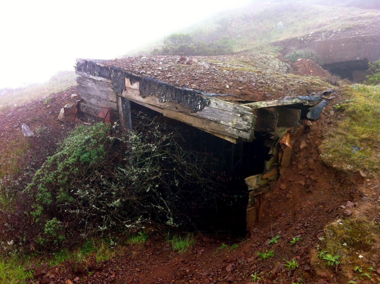
More dilapidated military cast-offs on The Loop, this time shrouded in mist. So happy the GGNRA bought the land when it became available in the 70's.


The gray and dismal day was not without a few wildflower fireworks. Yellow footsteps-of-spring are blooming along the trail, as are white milkmaids, fuchsia rock cress, man-root vines, purple bush lupine and these two beauties: stands of fragrant wild lilac and spindly, bright pink shooting stars.


Julie (you can barely see her, right?) and Linda on the Wolf Ridge Trail. The sunny views north to Mount Tamalpais and Tennessee Valley were obscured by the low clouds, but it was delightful nonetheless.
  

Another artsy-shvartsy picture of the elements that day. It's the same old trail, but it never disappoints.


*  *  *

One hour and fifty-five minutes after we began, Rodeo Lagoon greeted our approach to the parking lot. I've hiked The Loop in an hour and forty before, but we were in no hurry and dallied along the way, so content to be with friends exploring dreary, beautiful Marin County.

Then two things happened. In the lagoon a bright black, shiny head poked up from the water: a river otter! These critters are rare in our neck of the woods; I've seen them only once in 24 years of hiking the Bay Area, so we paused for a sec to watch his/her antics. A few strides further, by the sleek wooden bridge that spans the lagoon to the beach, Julie noticed a Marine Mammal Center truck pull in and park. Pull in and park and hoist out a large, boxy cage! We couldn't see what was inside, but it was obvious by the origin of the truck. A few questions later, we knew we had stumbled upon another rare sight and another first for us all: a honest to goodness sea lion release!

The 400 lb. beast was first seen on Pier 39 in San Francisco with some sort of plastic packaging material wrapped around its neck. Being a somewhat hefty, aggressive fellow in an awkward location they couldn't walk up and net the thing, so they decided to artfully tranquilize it, take it to the center, remove the stranglehold, tend to the infliction and release it on the day we walked past. So without further ado here's an unscheduled detour: a video of something one doesn't see everyday (excuse the wind shear), a video of a sea lion named Dartman returning home.


*  *  *

Pleased as punch and back at the car, Julie asked us if we had any deadlines for the rest of the day (we didn't), quickly phoned her brother Dennis, and after a brief stop at Molly Stone's I found myself on the deck of a classic, 1960's era Chris✭Craft berthed in Sausalito.

I had a cool pilsner in hand, to boot.

Behind the protective coastal hills it was warm, calm and partly sunny, but the clouds continued a moody march across the sky. From land the view would have been (and was) gorgeous, but we were about to take an unscheduled bay cruise.

Pudgy harbor seals and sleek black cormorants watched as Dennis eased his beautifully-appointed motor yacht into Richardson Bay, and for the next hour we slowly puttered about, took turns manning the helm, and munched on veggie sandwiches, beet salad and Tim's Cascade Style potato chips.

It's fabu enough to have a boat and someplace to put it, but Dennis has a killer berth on the Sausalito docks: there's nothing on one side but a line of wildlife and open water.


Mayday! Mayday! It's Julie at the helm!


Another unexpected visual treat: A pair of tall ships was on the bay, staging a life-like combat complete with actual cannon blasts. No large iron cannonballs arced through the air, but there were puffs of white smoke and a big BOOM when they did the business.


Artsy-shvartsy photo alert!


Dennis Ring, with his first mate Linda (for now) and sister Julie: The master of his Chris✭Craft domaine. I can't wait to return (if I'm invited).


*  *  *

So there you have it, cyberhood. Just when I thought I'd spent enough time in Marin, in the tired old Headlands, had seen it all, hiking that same old tired Loop trail, yada yada yada. Hmmm...Guess not.

Surprise!
Peter J. Palmer


Tuesday, January 24, 2012

Blubber is Back!

One of the coolest things about living in San Francisco, at least in my opinion, is the city's close proximity to areas of true wilderness. From the steel and concrete skyscrapers of the Financial District and bustling shopping mecca of Union Square, a landscape unblemished by the hand of man is easily within reach: the Marin Headlands, Mount Tamalpais, Point Reyes National Seashore, the Santa Cruz Mountains. From the white-noise, urban drone that hangs over parts of our city like a cloak of fog, the primal, untarnished voice of nature is never far away. The eerie howl of coyotes, the whisper of nothing but wind, the piercing screech of a raptor, the rumble of beach rocks being swept back underwater by a receding wave, the warning call of rattlesnakes and bobcats and Tule elk, the elusive hoot of an owl.

Or, in the case of the animal we're gonna discuss today, the noise something might make if it belched - really letting one rip - deep inside a rusty, 400-gallon steel drum. Oh, and in Dolby THX to boot.

*  *  *

Tucked away in a quiet, scenic but unremarkable stretch of the San Mateo coastline, less than 90 minutes south of San Francisco by car, one of nature's most outrageous wildlife displays is now underway. A drama, a love story, sometimes a tragedy and always a comedy: it's a Spectacular! Spectacular! starring some of the homeliest characters ever imagined, recorded in Surround Sound (Earthquake with Geneviève Bujold, anyone?), and staged on the sandy dunes and rocky point of land named Año Nuevo.

Behold mirounga angustirostris, if you will: the northern elephant seal. Truly something only a mother could love.

Photo courtesy of California State Parks

Eighty percent of an elephant seal life is spent at sea, but during the cold and rainy winter months thousands come ashore at Año Nuevo. In late December pregnant females arrive to give birth and nurse pups. The males, however - the BIG males, some of them weighing almost 2.5 tons, as large as an SUV big - are already there. They arrive first, stake out a prime claim on the beach and, of course, wait for the the belles of the ball: the, shall we say, Rubenesque females. Sexual intrigue ensues. And by March it's all over; some 1st year weaners remain, but most of the action has returned to life in the ocean.

Point Reyes has a colony elephant seals, as do several other sites on the California coast. That said, no place is more accessible and better for viewing than Año Nuevo State Reserve, and few have a larger population. For much of the year you can hike out to see the beasts on your own (they come ashore again to molt), but during the intensely competitive winter breeding season you need to snag a reservation for the 2.5 hour docent-led walks from the visitors center out to the colony.

Tuesday, January 17, 2012 was my third trip to Año Nuevo. Each visit was fantastic, fantabulous, unforgettable, but this most recent one was blessed with clear, sunny skies (walks go rain or shine, and my two previous ones were pretty cold and wet), plus had a surprise encounter with a big male sneaking up behind us in the dunes.

*  *  *

Here's a link to an iMovie I stitched together and posted to YouTube after my last trip.


Here's the link to a page with some official, scientific information on our population of elephant seals.


Whenever you're ready to schedule an outing, here's a link to the State Park website.


*  *  *

And now for my own cinematic review of the festivities: Why you should go. Now.

The drama: Watch two 6,000 pound males go at it. Watch the beach master try to defend his harem, his breeding rights, and tell me it not just as riveting as Spartacus on the Starz Network.

The love story: There's nothing quite like the sight of an alpha male violently coercing a much smaller female to mate. Even if she's ready.

The tragedy: Unfortunately, the mortality rate for newborns is high. Danger abounds, and infant elephant seals get trampled in the melée all the time.

The comedy: Just look at them. They may be skilled aquatic swimmers and hunters, but just watch them try to make their way on land. And what's up with that proboscis, that bizarre nose? Scientists still can't figure out the purpose of such an odd, ungainly feature, but perhaps Mother Nature simply has a wicked sense of humor.

*  *  *

So pack a lunch. Pack a water bottle and gloves and a hat and a rain slicker and an extra layer just in case. Make a reservation or take your chances. Who knows? I may see you out there, once more before the final screening this year.

Happy trails!
Peter J. Palmer


Saturday, January 7, 2012

At Home

Happy New Year, cyberhood!

Quick post to kick off 2012, but one with lots of pictures, detailing a newly improved hike within the San Francisco city limits. It's named the Batteries to Bluffs Trail (an offshoot of the Coastal Trail), and the two combined will lead you from the south end of the Golden Gate Bridge to the hills above Baker Beach.

The hike is not that long, just about 3 miles round-trip, and although there are a few significant ups and downs in both directions it's not that difficult. It is, however, right in our own backyard, and is accessible by car, on foot, by bike or by bus. If you're visiting or live in the northern part of the city you don't have to drive; simply make your way to the lovely Fort Mason District and catch the #28 bus west to the GGB (consult SF MUNI schedules and routes). Once off the bus - after you take in the impressive views on this side of the bridge - you want to find the paved bike path by the visitors center that leads under the roadway (not down to Fort Point).

The Golden Gate Bridge, of course,
with the Civil War era Fort Point below.

The dirt track Coastal Trail starts on the outside of the bridge and heads south, passing some old military installations that you may want to explore along the way, and immediately offers spectacular views of the coast and the mighty Pacific, back toward the bridge and north to the Marin Headlands. The trail here is bit confusing (there's actually several footpaths lacing about the bluffs), but keep heading south and you'll soon see more signs.

Batteries to Bluffs officially opened in 2007, I learned, but the area is still a work in progress, especially at the beginning of the trek (still the Coastal Trail, I guess) where some construction gear competes with the natural beauty. Once past Battery Godfrey (est. 1895) the views open up to naked cliffs (pun intended), and the actual new trail begins. As it starts to descend you'll probably see some hardy park employees along the way, picking through the hillside bluffs in an effort to eradicate invasive plant species (hopefully avoiding the significant amount of poison oak). It's a massive restoration project, funded partly with generous donations to the GG National Parks Conservatory, but once finished the entire seaside will be cloaked in native flora. You'll recognize the park employees because they'll be wearing clothes. Yup, you're in nudie territory here.

The Batteries to Bluffs trail now allows hikers safer access to what's apparently called Marshall's Beach (hmm...been coming here for years and never knew that), the stretch of sand north of Baker Beach (part of which is also nude); when the tide's out the last significant beach before the Golden Gate rises above you.

The beginning of the Coastal Trail seems like it's gonna be wheelchair friendly when it's finished (albeit ATV wheelchair - LOVE California!), complete with access to an impressive, state-sanctioned lookout point just before the stairs begin. At the nadir of the descent, at the spur trail to Marshall's Beach, there is a newly unearthed natural spring that gurgles down from the hills above. I don't know the name of the spring (or if it even has one), and the surrounding earth is a bit raw right now, but it's a welcome surprise nonetheless.

Time to climb. It's not that strenuous, but it is up. Up to some more beautiful views and rugged coastline, ending soon with a postcard perfect perch above that gorgeous crescent of urban sand: Baker Beach.

(FYI. When the tide is nice and low, and should you crave some real risky and risqué exploration, at certain spots you can get beachside and wend your way (i.e. bolder hop) along the coast at waters edge, keeping an eye on the ocean at all times. Be forewarned, tho: it's dangerous, not recommended or sanctioned, and the wildlife can, in fact, be wild.)

The Batteries to Bluffs trail rejoins the Coastal by Battery Crosby (est. 1900). Here you can sit a spell and admire the view, or continue on and access the log steps down the dunes to Baker Beach proper for a picnic (beautiful sand and surf, great people-watching, picnic tables and restroom facilities). And should you desire an all-day trek you can continue walking the rest of the Coastal Trail to Land's End, Sutro Baths, the Cliff House and Ocean Beach (another 2 miles). Or you can turn around and retrace your steps.

Any which way you're gonna love it.

*  *  *

The following pics are from September 2011. As you can tell many are with the Golden Gate Bridge in the background, but the views are so spectacular and so rewarding from this vantage point that I had to include them all.

The start of the hike,
with the cove at Baker Beach in the distance.

Battery Godfrey detail.
I love the old cement and iron shapes.

Looking back on the Coastal Trail.

The descent on Batteries to Bluffs trail.


After the climb.  Getting closer to Baker Beach.

The view from above to the beach below.

On the return hike.

Wildlife (not guaranteed): I've seen gray whales, harbor porpoise,
Pacific white-sided dolphin, bottle-nosed dolphin, sea lions, pelicans,
cormorants, snowy plovers, oyster catchers.


A short video from September, taken from the rocks by Marshall's Beach.


These are from a recent visit in January 2012. Weird weather; more like our glorious month of February, because January is usually rain, rain, rain. Don't know what's up with Mother Nature this year, but we'll see.

As I sat and watched, the bridge would disappear in the fog
then re-emerge in a matter of minutes.  It was gorgeous.

Marsall's Beach with a good low tide.


One final video. Same view but different weather.


The following pictures are from Land's End (Sutro Baths, the Cliff House and Ocean Beach), which is another 2 mile hike from the south end of Baker Beach. For visitors without a car (and city dwellers alike), a grand day out might include this itinerary: hop on the #38 Geary bus to the end of the line at 48th Avenue, spend a few hours exploring Land's End, then hike all the way back to the Golden Gate Bridge, where you can pick up the #28 bus to Fort Mason in the city (or do it in reverse).


Land's End above Sutro Baths, with the GGB in the distance.


The remains of Sutro Baths (1896-1966),
a fun place to carefully explore.

On Ocean Beach, with the Cliff House beyond.

Ocean Beach: beautiful, wide and long.


Happy trails,
Peter J. Palmer